ICW Information by ICW Statute Mile Marker
STM 801 to 900
Back to STM 701 - 800
Forward to STM 901-1000
Latest Update: 29 October 2018
Note: Cruisers can check real-time water levels in the Indian River Lagoon
STM: 803.1
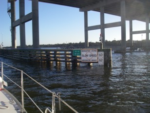
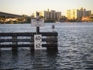
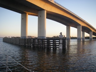
Fixed Bridge: Palm Coast Parkway
Transit reports, SV Onward:
Date | Time | HB N | HB S | EEH | Tide | Fenders | Comment |
31-Oct-16 | 1000 | 65.0 | 65.0 | 0.2 @ Flagler Beach | VHF tipped S beam | ||
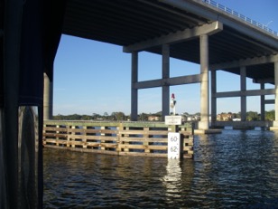
STM: 810.7
Fixed Bridge: Flagler Beach
Transit reports, SV Onward:
Date | Time | HB N | HB S | EEH | Tide | Fenders | Comment |
31-Oct-16 | 1050 | 64.0 | 64.0 | 65.5 | 0.2 @ Flagler Beach | VHF flicked S beam; -4-6" |
STM: 816.0
Double-Bascule Bridge: LB Knox
Note: Open on Request
STM: 824.9
Fixed Bridge: Ormond Beach
Transit reports, SV Onward:
Date | Time | HB N | HB S | EEH | Tide | Fenders | Comment |
14-Nov-10 | 64 | 64 | ~64.75 | 0.7 @ ICW Ormand Beach Halifax R ICW | WL @ top to bottom of 5th FB | 0.75 to 1' of VHF hit beams | |
14-Nov-14 | 1242 | 64.8 | 64.8 | >65.75 | 0.3' @ Ormand Beach Halifax R ICW | VHF cleared beams. Transit made on E side of CL | |
31-Oct-16 | 1248 | 64.1 | 64.1 | 64.75 | 0.7 @ ICW Ormand Beach Halifax R ICW | ~1' of VHF hit beams | |
- Note:
- Tide data (Nov 09) reports minimal tidal swing in this area.
Ormond Bridge N Height Board 14Nov10
Ormond Bridge S Height Board 14Nov10
STM: 829.2
Fixed Bridge: Seabreeze
Transit reports, SV Onward:
Bridge | Date | Time | HB N | HB S | EEH | Tide | Fenders | Comment |
Seabreeze | 14-Nov-10 | 63.0 | 63.0 | >65.75 | 0.7' @ Ormand Bridge, Halifax R ICW; 2.6'@Daytona; 2.0 @ Ponce de Leon Inlet | WL @ ~top of 4th FB | VHF clearned beams on CL | |
| Seabreeze | 14-Nov-14 | 1242 | 64.8 | 64.8 | >65.75 | 0.3'@ Ormand Bridge Halifax R ICW | VHF clearned beams on E side of CL | |
| Seabreeze | 31-Oct-16 | 1320 | 63.0 | 63.0 | >65.75 | 0.7 @ ICW Ormand Beach | VHF cleared N bridge ; ~0.25' hit S beams | |
Note:
- E side of channel appears to have greater clearance. May be an optical illusion.
Seabreeze N Bridge N Height Board 14Nov10
Seabreeze N Bridge S Height Board 14Nov10
Seabreeze S Bridge; S Height Board 14Nov10
Seabreeze S Bridge N Height Board 14Nov10
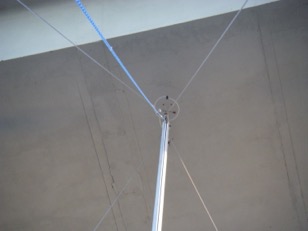
Onward clearing the Seabreeze N Bridge 14Nov 10; tip of VHF at 65.75' is not touching at center of bridge arch.
Bridge Transit Report: Seabreeze Bridge
Vessel Reporting: Onward
Date: 20 Nov 2009
Report: Height boards read 63.0’. Following the centerline of the concrete arch, the tip of Onward’s VHF antenna (~ 65.25’) did not touch the N bridge and just flicked the arch of the S bridge. The nearby bridge tender related that bridge height boards have apparently been cha
nged to reflect the clearance over the fenders vs the center of the span.
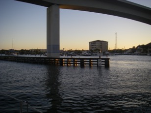
STM: 829.7
Double Bascule Bridge: Datona Beach Main Street
Note: VHF-09 A great bridge tender!
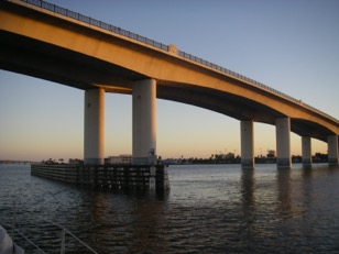
STM: 830.2
Fixed Bridge: C Carlton Black
Transit reports, SV Onward:
Date | Time | HB N | HB S | EEH | Tide | Fenders | Comment |
20-Nov-09 | 62.25 | 62.25 | >65.75 | WL @ bottom of 5th FB | VHF cleared beam on CL of arch | ||
14-Nov-10 | 62.25 | >65.75 | 2.0' @ Ponce de Leon inlet | WL @ bottom of 5th FB | VHF cleared beam on CL of arch | ||
31-Oct-16 | 1330 | 62.8 | 62.8 | >65.75 | WL @ top of 6th FB | VHF cleared beam on CL of arch |
- 20 Nov 2009 The nearby bridge tender related that bridge height boards have apparently been changed to reflect the clearance over the fenders vs the center of the span.
- The lights on the CL hang below beam and have wire loops to E on N and W on S sides.
Carlton Black Bridge N Height Board 14Nov10
Carlton Black S Height Board 14Nov10
STM: 830.6
Double Bascule Bridge: Daytona Beach Memorial
Note: 27 Oct 18; the Memorial bascule bridge has been removed. Construction is nearing completion on a high rise fixed bridge to replace it; the bridge deck over the channel was not in place at this time giving a clearance of ~70'.
STM: 830.7
Nav. Marker / Location: Memorial Bridge Anchorage
STM: 835.5
Fixed Bridge: Port Orange
Note: 27 Oct 18; The center span over the channel is being repainted. Half the channel width is supposed to be at full clearance. However the contractor has debris collecting structure which reduces the clearance by 6 to 12" - in violation of USCG requirements.
Transit reports, SV Onward:
Date | Time | HB N | HB S | EEH | Tide | Fenders | Comment |
20-Nov-09 | 63.25 | 63.25 | ~65.25 | WL @ middle of 5th FB | ~0.5' of VHF hit beams | ||
14-Nov-14 | 1445 | 63.1 | 63.1 | ~64.75 | 2.4' @ Ponce de Leon inlet; just after HT | WL @ top of 5th FB | ~1' of VHF hit beams. Hanging center lights with loops. Made SB transit on NW to SE diagonal. |
31-Oct-16 | 1410 | 63.75 | 63.75 | ~65.0 | 1.0 @Ponce de Leon inlet | WL at middle of 5th FB | ~0.75' of VHF hit beams |
- 31 Oct16 @ 1425; Saw 7.1' near G69
Nav. Marker / Location: Ponce de Leon Inlet
Vessel Reporting: Onward
Date: 27 Oct 18: the inlet is being dredged. The SE section at the channel junction has been dredged. The dredge was working on the N section. In the N section depths of 7' near low tide were encountered.
STM: 842.3
Nav. Marker / Location: Rockhouse Ck Anchorage
Vessel Reporting: Onward
Date: 20 Nov 09
Report: Anchored at W mouth of cut in 10-15'. Due to current and wind interaction boats needed greater separation to account for uncoordinated movement of boats at anchor.
STM: 845.0
Single-Bascule Bridge: George Munson
STM: 846.5
Fixed Bridge: Harris Saxon
Transit reports, SV Onward:
Date | Time | HB N | HB S | EEH | Tide | Fenders | Comment |
21-Nov-09 | 66.0 | 66.0 | >65.75 | 1.6' @ Ponce de Leon inlet | WL @ top of 4th FB | VHF clear | |
31-Oct-16 | 1535 | 67.0 | 67.0 | >65.75 | WL below 4th FB | VHF clear |
STM: ~849.0 Anchorage
There is a good anchorage, long and narrow with depths of 9 - 14' parallel to the main channel on the E side S of the bridge. The anchorage can be entered from the ICW by passing DM G45 close by on either N or S side.
STM: 869.1
Nav. Marker / Location: Allenhurst Bridge; Haulover Canal
Double Bascule
Opens on request
STM: 876.6
Single-Bascule Bridge: NASA RR
Note: Remotely operated; Normally open
STM: 878.7
Fixed Bridge: Titusville [Formerly Max Brewer Swing Bridge]
Transit reports, SV Onward:
Date | Time | HB N | HB S | EEH | Tide | Fenders | Comment |
15-Nov-14 | 1100 | 66.5 | 66.5 | >65.75 | NTA | NFB | |
| 1-Nov-16 | 0930 | 66.2 | 66.2 | >65.75 | NTA | NFB | 3 lights on each side haing below beams with wire loops to W |
STM: 885.0
Double-Bascule Bridge: NASA Causeway / Addison Point
STM: 893.7
Nav. Marker / Location: Canaveral Barge Canal Junction
STM: 894.0
Fixed Bridge: City Point
Transit reports, SV Onward:
Date | Time | HB N | HB S | EEH | Tide | Fenders | Comment |
21-Nov-09 | 1430 | 64.25 | ~64.75 | NTA | WL @ middle of 4th FB | ~1' ov VHF hit beams on N span; < 0.25' on S beam of S span | |
1-Nov-16 | 1130 | 64.4 | ~64.5 | NTA | WL below top of 4th FB. | ~1.25' of VHF it beams of N span which is lower than S |
STM: 897.6
Fixed Bridge: Cocoa
Transit reports, SV Onward:
Date | Time | HB N | HB S | EEH | Tide | Fenders | Comment |
21-Nov-09 | 0700 | 63.1 | 63.1 | ~64.75 | NTA | WL @ middle to bottom of 4th FB | ~1' of VHF hit beams. |
15-Nov-14 | 1335 | 64.0 | 64.0 | ~64.75 | NTA | WL @ middle of 4th FB | ~1' of VHF hit beams. |
1-Nov-16 | 1200 | 63.75 | 63.75 | ~65.0 | NTA | WL @ middle of 4th FB | Danger: contractor has cables across navigable channel that reduce vertical clearance. ~0.75' of VHF hit beams |
Notes:
- Nov 2009; High Priority, a sister ship to Onward, reported that they had safely passed under the bridge about 12 Nov 09 at a HB reading of 62’.
- Between the Nov 09 passage report and the Nov 2014 and 2015 reports, apparently the height boards were changed to read about 0.5' more clearance at the same water level as they did in 2009.
Cocoa Br. N; Nov 2009
Cocoa Br. S; Nov 2009
Back to STM 701 - 800 Forward to STM 901-1000